![]()
Elevation View-Concepts
The Elevation View commands allow user to specify an orthographic view parallel to the Z plane, looking at your environments from one side. The specified orthographic view presents a two dimensional view representing the exact shapes and locations of entities in AGi32 seen from one side. No object depth is seen and all lines are displayed (no hidden line removal is available).

AGi32 provides two ways to specify Elevations Views. Primary Elevation views (Looking North, South East or West) allow the user to specify the View location with just one click. The Elevation View-Specify command is used to specify any orthographic view, even non primary views, by selecting two point along the Viewing plane.
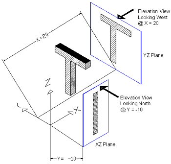
Primary Elevation Views Looking North and South extract the specified Y coordinate to create the orthographic view. The specified view will exist in the XZ plane. Primary Elevation Views Looking East and West extract the specified X coordinate to create the orthographic view. The specified view will exist in the YZ plane.
Elevation Views are depth aware. Entities located in the Viewing plane or in front of the viewing plane (in the View direction) are visible; entities located behind the Viewing plane are not.
Once in an Elevation View, you may shift the Viewing plane forward or back by using the Page Up and Page Down keys keyboard keys. Each press of the Page Up or Page Down keys will result in one step forward or back. One step is equal to one Snap increment. For example, if you specified an Elevation View Looking North at Y=0, and the current Snap increment equals 1, then using the Page Up key will move the Viewing plane to Y=1.
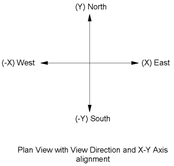
Cartesian Axis Alignment
